Bailey Range Traverse and Mount Olympus
Overview
In the spring of 2025, Nate Philip and I were climbing together when he mentioned that he was attempting the Bailey Range Traverse and trying to climb Mount Olympus along the way (called the BRTO) with a friend of his, Sean. Being clever and conniving, I invited myself along, politely.
This became the most intense four days of “backpacking” I’ve ever had. I say “backpacking” because only about half of the trip was on a maintained trail. The second day and most of the third was fully off-trail, on ridgelines, through meadows, and across glaciers.
Nate didn’t sugarcoat the route while pitching the plan, that’s sort of what made it so attractive to Sean and I! That plus he did all the legwork, planning and permitting (and driving! What a guy!).
The stats:
- 4 days, 3 days
- 45 miles, 20,000+ feet of vertical gain
- 9-12 hours of moving every day (this was conservative…)
- Many, many calories
- Constant wet feet
Overall the trip was incredible - a bit spicy, a bit mentally exhausting, a lot physically exhausting but continuously beautiful. Getting to climb out of a rainforest and across glaciers to summit Mount Olympus with a pitch of real rock climbing was incredible.
Here’s our route:
Day 0
I pack carefully. I make a spreadsheet to track my calories. I portion food into small bags for separate meals and separate days. I read about calorie density and macros and other things I feel like I should already know. I am being more meticulous than I have before about what gear and food I pack because I am nervous about how hard this will be and planning like this makes me feel better. Also I can only fill half of my bear can because Sean needs to cram his food into the other half in the evenings.
On Wednesday, Sean picks me up and we drive to Edmonds to meet Nate. Traffic is not great, and Sean has plenty to say about it but we make decent time. We pull into the Park-n-Ride immediately behind Nate and we carve parallel turns as both cars park in a nearly empty lot. It feels very cinematic, timing like that is rare and fun and we joke about it as we transfer gear into Nate’s car.
We get on the ferry and drive to the Sol Duc trailhead. Outside of Port Angeles we stop at a Grocery Outlet because I’ve forgotten my cheese, critical for backpacking success and often forgotten.
The road to the trailhead takes us past Crescent Lake, the golden rays of the setting sun making the lake look absolutely spectacular. I am quite jealous of those houses scattered about its far shore. I am also very appreciative of a trailhead that has a fully paved road all the way there.
At Sol Duc, Nate parks next to a grassy strip and we make “camp”. Camp, as it were, for me at least, is a thin air mat on top of my thin foam mat, next to Nate’s Subaru. Nate and Sean cozy up inside the car on a fitted mattress. I sleep better than I think I will, but still terribly.
Day 1 - Solduc Trailhead to Stephen Lake
I wake up at around 5am, with my quilt covered in a thin drizzle. I quickly try and dry it off and stuff it away, then just sort of wander around the lot waiting for those other two boys to wake up so I can get my food out of the car and eat something.
We hit the trail around 6:30am and hike uphill in a thick fog that turns to rain several times throughout the day. We can’t see what must be sweeping panoramas on our way up because visibility is terrible but otherwise the hiking is easy. At Heart Lake we leave the main trail and immediately start to get soaked by the dripping foliage. Beargrass and ferns and cedar trees, saturated, drip water down our legs and into our shoes. I’m squishing water between my toes within the hour.


We move quickly through sidehills, always the trail is there but also just a bit too hard to find and too easy to lose. We spend a lot of time trying to spot it after it peeters out. Often we find ourselves pushing through or around small cedars, soaked in water. We call them Olympic Car Washes.

We come to a gully that’s fully washed out, steep embankments on either side. It’s loose and steep and the ground is pretty wet. We can’t see an easy path into the gully, I try to get in up higher but it’s consistently crummy and dangerous. Eventually Nate pulls out his ice axe and cuts steps into the gravelly sides and Sean and I gratefully follow his steps.

Back on the trail, sopping wet. We get lost in another ravine, heading straight up when we should have stayed low. It’s raining pretty good at this point and the foliage and loose rocks are slick. I get pretty nervous about continuing, at one point we basically need to kick steps up this steep, saturated moss covered cliff. The ground squelches below our steps, and releases water like stepping on a sponge.
We eventually are able to drop back down and regain the trail. Attempting to get down to the trail through wet foliage, I lose my footing twice, the second time sliding a foot or two until I basically land on my butt directly on the trail. Excellent.
Turns out on that slide I had dropped my phone! About 10 minutes down the trail I realize what’s happened and Sean comes back with me, finding my phone in part because he had coincidentally started a GPX track on his phone at the same time as my fall? Weird and quite lucky. I had already accepted that the phone was gone.
Finally, we push up a steep meadow and summit a ridge and get a view of Stephen Lake.


In the clouds, it looks small, and close but as we drop lower we can see that the lake is enormous and gorgeous. It takes us awhile to get around the lakeshore. Nate and Sean find a camp on the far eastern ridge. I filter some water. It’s a beautiful sunset, as if the whole day of getting soaked didn’t actually happen. The lake inlet is a wide, gravelly delta with bright patches of moss. Tall peaks surround the lakeshore on its south and east side. The sun perks our enthusiasm and turns a type 3 fun kind of day into a type 2. In the golden rays of sunset, it’s easy to remember that, right, this is why backpacking is so amazing. We eat loads of food and sleep well.

Day 2 - Stephen Lake to the foot of Humes Glacier
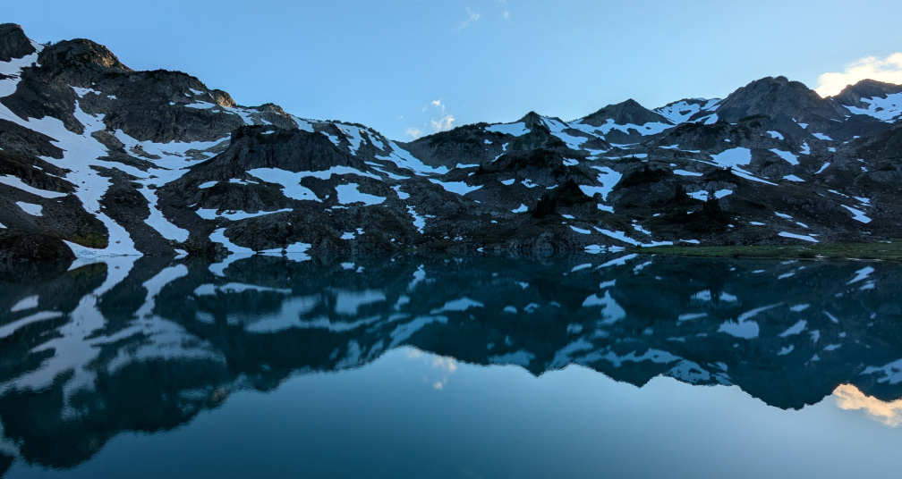
Bright and clear morning. My body feels surprisingly good, limber, not super crampy. Not much lactic acid build up and no dehydration headache. These are good signs. The sunrise over the lake is perfect. The snow bands contrast with the rock, the clouds are whispy. Incredible job, I have no notes.

We get a late start, taking almost two hours to break camp. Another group of two pass us as we are packing and we shout a greeting. We will end up following their bootpack all day but will never catch up to them, they’re blazingly fast.

We climb a gully, hugging a stream and follow the lowest angle terrain over the shoulder of Stephen Peak. We spend a lot of time following the ridge, stopping to transition to crampons and axes occasionally. Progress is slow but the views are exceptional.


These high ridges still hold lots of snow, creating large bowls and cirques, the ridge itself is spiked and shattered, brutal rock. We stop for a quick lunch at the first flowing water we have seen in several hours. I filter some water and eat quickly. A bit anxious as the day is hot, and we are moving pretty slowly given that we’re less than halfway to our intended campsite.


We snow-ski down an enormous basin. Waterfalls and mossy cliffs abound. Mountains surround us and we FEEL ALIVE!
This is a really nice and remote section of the trail. We ramble across a meadow, wide and full of blooming flowers. The Qeets River cuts a chasm into a cliff and the water jets out, powerful and gorgeous.


We follow elk trails downhill to the river crossing. It feels…natural and also bizarre to be taking directions from animals but why not? They will be ambling downhill in search of the same thing we are - an easy crossing. We make relatively good time to the river, crossing, we brush-bash uphill briefly before finding a decent trail. We aim for a rock gully seen from the satellite imagery.

After a few hundred feet of dense alder that tries to pull our hats, ropes, backpacks off our bodies, we break through. This section is pretty tiring and lame, dampens our spirits for the day. We are already tired, it’s 5pm. We reach a cliffband that guards the glacier terminus. We need to climb the cliff somehow and the only trip report we remember is one that suggests a loose but lower angle scree band around to the right. We make a collective but bad decision to attack this scree band rather than scrambling steeper terrain around left. I go too high and have to wait while the others cross below me. This is scary and definitely dangerous and I can tell we’re all nervous. Luckily we have our helmets on and our axes out.
We eventually make it to the base of the glacier - broad gravel bars surround the lake. Distant ice and rockfall thunder around us and we need to make a decision as it’s getting late, with fading light and several miles on snow to go before our intended campsite. We are all tired and mentally burned out from the scree experience.

We chat - Nate wants to stay here and skip the summit push tomorrow. Sean wants to stay here and still push attempt the summit. I am happy to go along with the conservative plans although I feel like I have the energy to push further. Mostly I feel dumb that we took such a risky route up the cliff without exploring more! In retrospect, we should have done a better assessment before committing. We talk as a group, exploring how we feel. “Not great!” is the consensus, so we camp high, away from any rockfall. We talk timings and turnaround points for tomorrow. We decide on a 4am departure and all turn in early. The sun falls behind the cliffs, glowing on the walls and exposed ice of the Humes Glacier. Light winds overnight, thankfully, allow for easy sleep.
Day 3 - Humes Glacier to Mount Olympus to Lewis Meadows
Rising early, I down a slurry of oats, protein powder and oil. I know, right!? Gross! But it’s surprisingly delicious and I’m considering an update to add my coffee powder directly into the slurry. One-stop shop.

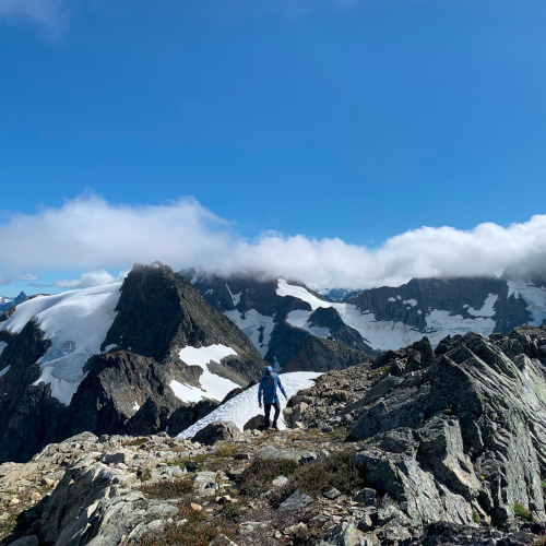
We gain the glacier easily, the moon is crazy bright, and we move quickly over the first pass. Camp Pan lies on a rocky promontory over the glacier carved valley. Perched precariously on the cliff edge, it’s one of the most stunning campsites I’ve ever seen. The clouds swirl dramatically below us in the morning light like ocean waves caught in a basin, the tips catch the first rays of sunshine and glow gold.


We are all agape, the views here are powerful and a reminder what is so compelling about these wild places. We’re miles from a maintained trail, days deep into the backcountry. It’s 6am and we’ve been moving for hours already. My feet are soaked but THIS, this is why I come here. I have to restrain myself from taking the same picture a dozen times.


We move around a cliff band and drop to the Hoh Glacier and cut a direct line to the next pass - Blizzard. From there we can see the summit trail and a string of climbers already cresting Snow Dome, a false broad summit plateau.
Halfway across the Hoh and we hit the sun line. Knowing we won’t be back in the shade for many more hours, Nate wisely stops briefly to eat, pee, apply sunscreen.


We join the main trail at the far side of the glacier. We stash our overnight gear on some rocks by a stream of meltwater. The day is hot and water is pouring off every cliff face - waterfalls fully disappear into bergschrunds, cutting rivers under the snow.
We transition off the rope and plow uphill. A straightforward glacier crossing after Snow Dome then we mosey up the headwall, over narrow snowbridges. This is pretty easy, thankfully. It doesn’t feel that steep and Nate is setting a good, steady pace at the head of our rope team.

We crest the final snow headwall to the single pitch of 5.6 rock climbing to find that we are 13th in line for the summit pitch!

We get up without incident.

Downhill is warm, sloppy snow. It’s past 2pm. Once on Blue Glacier, the ice is fully exposed. The surface look like tidepools - clustered around tiny pebbles that catch the sun and create a runaway melting effect. Some pools are deep, blue to black at the center. Moulins flow from the surface into unknown depths below.

We are finally off the glacier at 5pm. Over 12 hours on snow. We are hydrated and protected from the brutal sun exposure, but it has been a lot. And we still have eight miles on trail to get to our campsite. We’re all tired with wet feet.
At 8:30pm we find a lumpy spot in the crowded Lewis Meadows. It feels weird to have to squeeze our tent in amongst all these people. We feel a little crazy, after the three days we’ve had, seeing regular people swinging in hammocks and chatting casually with their friends. Who are you people!? We stumble around to filter water. Nate, with a bit of dramatic foreshadowing, examines his feet.
Day 4 - Lewis Meadows to Stephen Lake
Nate rises early and is inspecting his feet again. He doesn’t know if his feet are good to climb up and over the ridge to the High Divide Trail. It’s about 14 miles and 6,000ft vertically. He’s worried about his blisters and his swollen, bruised toenails.
After some discussion, we decide to lighten my load and I will hike alone to the car, at the Sol Duc Trailhead. Nate and Sean will hike 11 flat miles along the Hoh River and I will start to drive towards them when I get out. If all goes well, they will hitchhike towards me at the same time. We’ll have communication via our GPS devices, so it seems relatively safe and possible. The other option we discussed involves hitchhiking out of Hoh to Sol Duc (unlikely!) or hitchhiking to Forks and getting an Uber (pricey!).
Because we’ll all be on maintained, populated trails, splitting up seems safe enough. It’s obviously not a good situation to be in, but Nate doesn’t need help walking, so it’s more a preventative thing. I’m glad that he brought it up with Sean and I, and didn’t just push through until it became a more serious situation.
I take an emergency kit in Nate’s lightweight climbing pack and Nate takes my backpack, splitting weight with Sean. From there, there’s nothing much to report! It all went exactly according to plan.
I busted ass up and down the ridge, finishing 14 miles in 4.5 hours, jogging most of the flat bits. When I got to the parking lot, I washed myself down with the water jug and got the heck out of there - the lot was JAMMED with Sunday traffic. Along the way, I learned that Nate and Sean had found a ride to Forks and I picked them up. The whole situation went very smoothly for something that had seemed likely to be very problematic only a few hours earlier.
And that’s that. Another successful backcountry trip in the books. I’m very grateful to Nate for organizing, and to Sean for good company, stoke, and a VERY lightweight rope for the glacier travel. We all spent the next week recovering and eating an enormous amount of food to recoup our calorie deficit.